LIFE
How to climb Mount Fuji
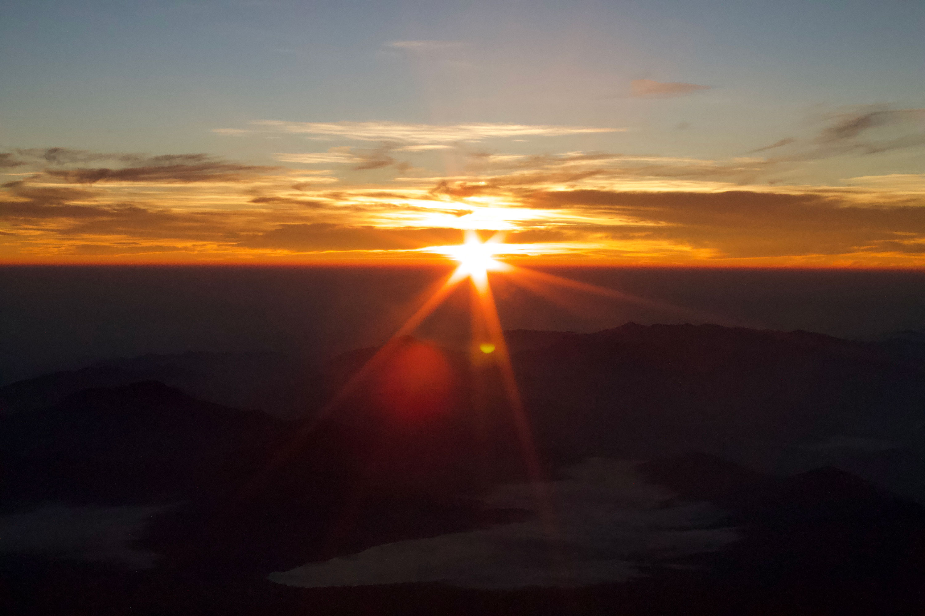
A comprehensive guideOrange is the new black: Climbers watch sunrise on Mount Fuji. OSCAR BOYD
Japan’s tallest mountain is a challenge to remember, if properly prepared
OSCAR BOYD
Staff writer
At 3,776 meters high, Mount Fuji is a symbol of the nation: standalone, vast and beautiful. A little over 100 kilometers southwest of Tokyo, and well connected by public transport to the capital, it is also one of the world’s most popular climbs — in 2018 alone, almost 300,000 people attempted the climb in the summer season.
Despite the numbers, and the infrastructure that has been built to serve them, the mountain is not without its challenges. Altitude is one of the most significant; there is little chance to acclimatize on the hike and, approaching 4,000 meters in height, the mountain is easily tall enough to induce altitude sickness in even the fittest of climbers. Another is exposure: Above the treeline there is very little shelter, Fuji is so prominent that nothing blocks incoming weather, and conditions can change very quickly.
However, to summit Mount Fuji is a great challenge, one that should be relished. The view of Japan from the top is unparalleled, especially when sunrise is thrown into the mix. With this guide, you should have an idea of what to expect from the mountain, and what is needed to make a successful summit.
When to climb
The climbing window for Mount Fuji begins July 1 each year, when the Yoshida Trail opens, and lasts till Sept. 10. The other three trails open July 10. During this time, all trails are well serviced by public transport, mountain huts are open and emergency services and first aid are more readily available. Bear in mind that weekends are much busier than weekdays, with Saturdays the most crowded.
It is possible to do an off-season climb of Mount Fuji — and even ski the mountain during the snowy months — but that requires specialist equipment and knowledge that is beyond the scope of this guide. In the off-season, huts are closed and there is no available public transport. Multiple fatalities occur each year among people trying to summit the mountain in the off-season.
Climbing strategy
In the summer climbing season, many people aim to summit for sunrise. This means climbing throughout the night — or at least a portion of the night — depending on your strategy.
The most direct way to climb is known as the bullet ascent — beginning your climb before midnight and climbing nonstop to the summit for sunrise. While this has many advantages, speed and low cost among them (and is my preferred method of ascent), it is not recommended by the prefectural governments that manage the mountain as it increases the chances of altitude sickness.
Each trail has a number of mountain huts, and a second strategy is to climb a portion of the mountain in the early evening, have supper and sleep at a hut, and then wake before sunrise to complete the ascent. This gives the body greater time to adjust to the altitude. A night at a hut with meals included will set you back around ¥10,000, depending on the day you climb, with weekends more expensive than weekdays. Huts are basic and often crowded; most offer little more than a futon on a tatami floor. Advance reservation is necessary if you hope to stay at a hut.
If you climb overnight, time your arrival at the summit to mere minutes before sunrise. Take it from experience that it becomes very cold, very quickly if you’re hanging around for hours waiting for the sun to rise.
Of course, it's possible to hike during the day, an experience that will be, in many ways, much more pleasant: less fatiguing (you don't have to miss a night's sleep), warmer and lighter. Missing the sunrise is a downside, but sunset can be be equally magnificent if you stay on the mountain long enough.
Prettier in person: Mount Fuji as seen from the summit of Takigoyama, a minor peak in Yamanashi Prefecture. OSCAR BOYD
Trails
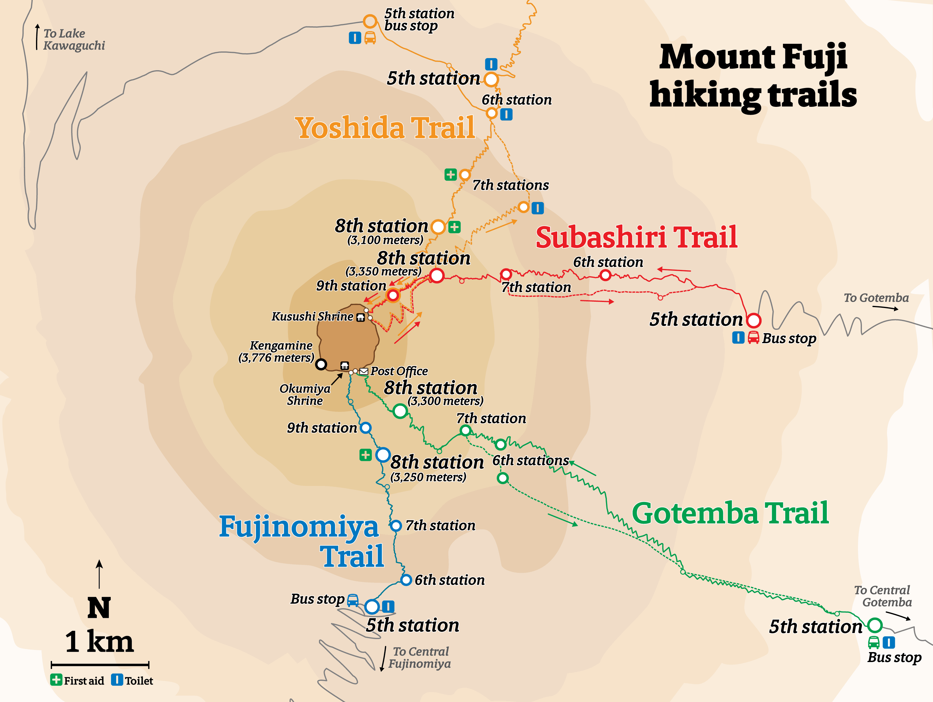
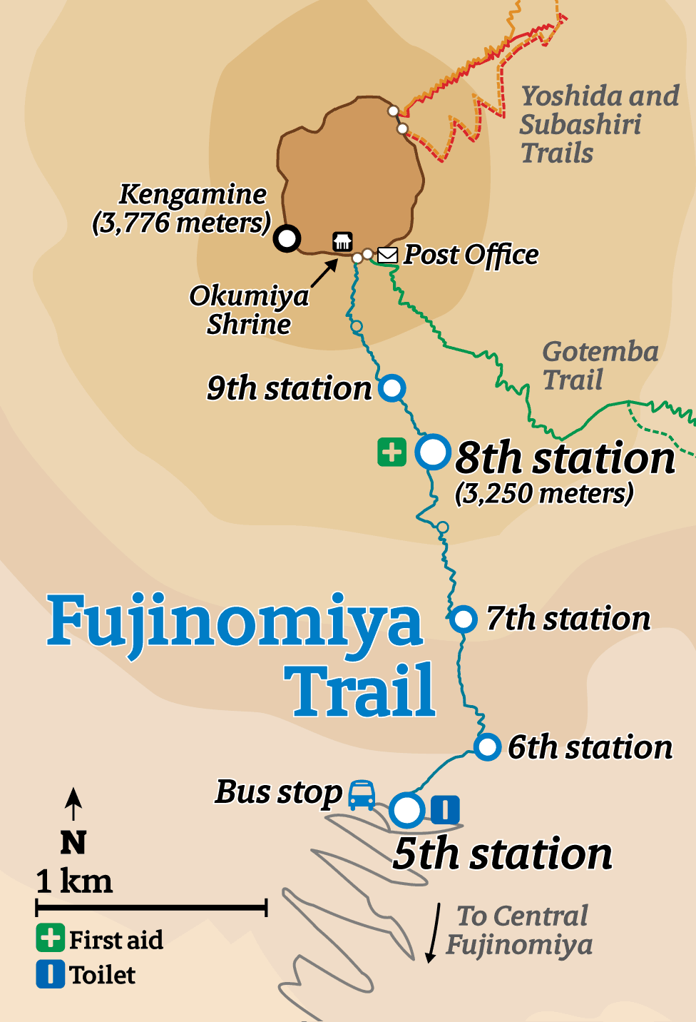
There are four main trails up Mount Fuji, each with different profiles, starting heights, visitor numbers and relative levels of difficulty. Each is broken into 10 stages, known as gō-me, and public transport runs to the fifth stage of each route, where most climbers start their ascent. During the summer season, buses to each of the fifth stations typically run from 6 a.m. to 8 p.m., depending on the trail.
Each route finishes at the 10th station (the crater rim), meaning it is possible to take different trails up and down the mountain, depending on where you hope to start and finish. While it is possible to climb from the base of the mountain, this is a significantly different challenge, not tackled in this guide.
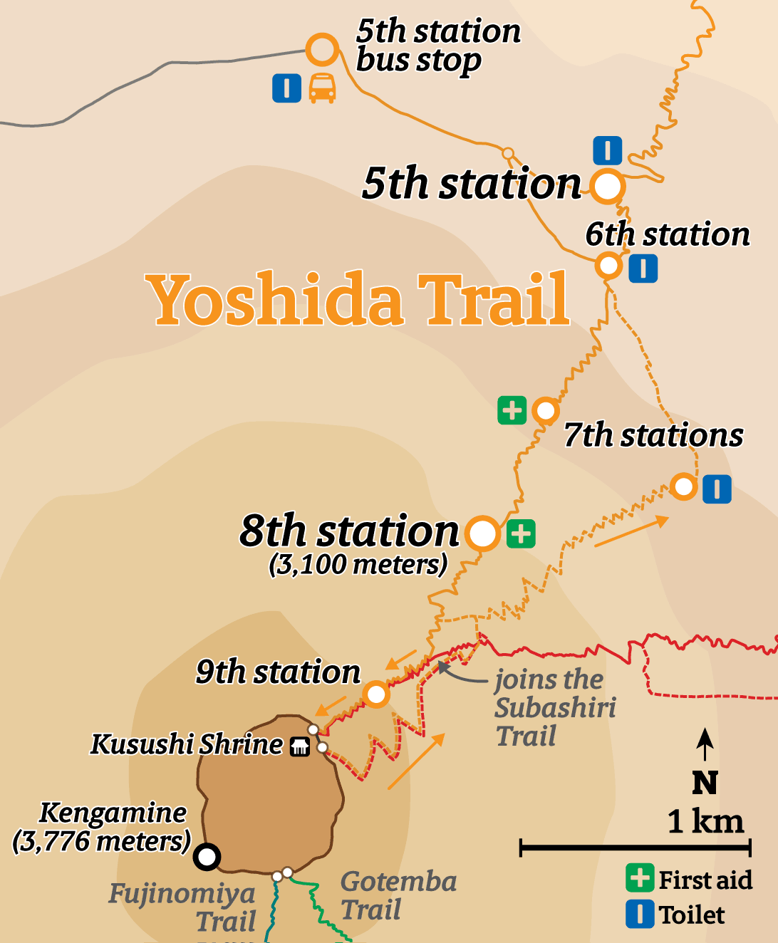
■ The Yoshida Trail
Starting height: 2,300 meters
Ascent: six hours; descent: four hours
The Yoshida Trail is the most popular, with around 170,000 climbers making the ascent via this route each year. There are first aid facilities at the fifth, seventh and eighth stations and mountain huts at regular points along the ascending trail. The descending trail is different to the ascending, a loose, gravelly surface that is almost easier to run down than walk. Watch out for the bulldozers that occasionally share this track. The start of the descent shares a trail with the Subashiri Trail, so make sure you stay on the Yoshida Trail when they split off from one another.
If you take security from being surrounded by lots of people then the Yoshida is for you. Otherwise, take literally any other route to avoid the hellish queues. A bus service runs to the trailhead from Kawaguchiko and Fujisan stations. Buses to the trailhead also leave from the Shinjuku Highway Bus Terminal.
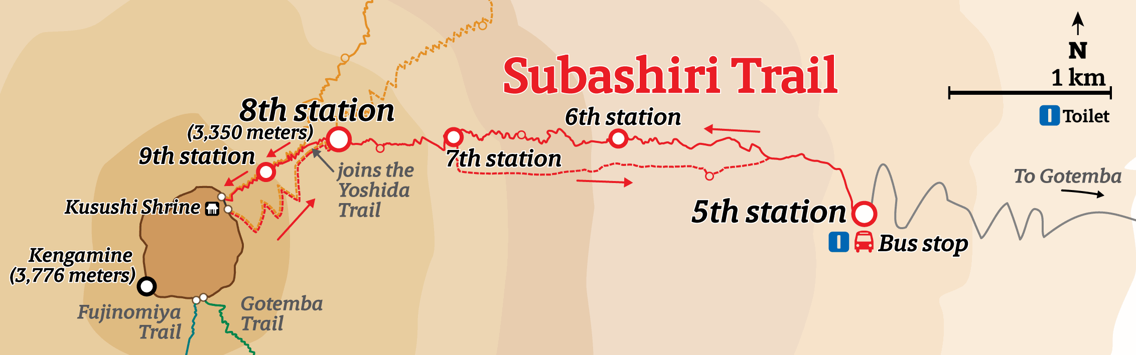
■The Subashiri Trail
Starting height: 2,000 meters
Ascent: six hours; descent: three hours
The Subashiri Trail is a close cousin of the Yoshida Trail. Though they start in different locations, they merge at the Yoshida Trail’s old eighth station (3,370 meters), meaning you’ll get the worst of the Yoshida crowds for the most difficult part of the climb.
The lower parts of the climb will be uncrowded, however, and offer a pleasing amount of variety that is not found on other routes. Ascending and descending trails split between the fifth and seventh stations, and there are no mountain huts on the descending limb. There are no first aid facilities along this route. A bus service runs to the trailhead from Gotemba and Shin-Matsuda stations.
■The Fujinomiya Trail
Starting height: 2,400 meters
Ascent: five hours; descent: three hours
My personal favorite, the Fujinomiya Trail is quicker than the others but steeper, following a relentless and rocky path to the top. There are huts at each of the stations and its popularity means some 70,000 people tackle this route each year.
The route is the same in both directions, and the descent is particularly tough on the knees. If you’re not tied to returning to Fujinomiya’s fifth station, consider descending via the Gotemba or Yoshida trails. First aid is available at the eighth station. A bus service runs from Mishima, Fuji, Shin-Fuji and Fujinomiya stations to the trailhead.
■The Gotemba Trail
Starting height: 1,400 meters
Ascent: seven hours; descent: three hours
By far the least crowded trail on the mountain, the Gotemba Trail adds a punishing 900 extra vertical meters when compared to the Yoshida Trail. The trail is gentle to start with, but soon turns steep enough, and is frequently loose underfoot, adding to its difficulty.
There are relatively few mountain huts on this trail, and those that do exist are congregated around the beginning and end of the climb. There is no first aid facility along this route. The descending limb splits from the ascending between the seventh and fifth stations, and is known for its “ōsunabashiri” (“great sand run”) path, a mix of sand and small stones that allows for a flying descent.
The Gotemba Trail is one for those who don’t mind suffering through a long night on the mountain, and the reward is far less company. During the day, a bus service runs from Gotemba Station to the trailhead.
The summit
Relatively few people visit Kengamine, the true summit of Mount Fuji — marked by its weather station at 3,776 meters — and are content with stopping where their chosen route meets the crater rim. Kengamine is best accessed from the Fujinomiya and Gotemba trails, and is a good 30-40 minute walk from the top of the Yoshida or Subashiri trails.
The crater is vast, over 500 meters across and 250 meters deep, and snow can be seen even late in the year. At the top of the mountain is a shrine and a post office, as well as several huts serving food, snacks and selling supplies — at a significant premium. The summit is particularly crowded around sunrise, especially near the top of the Yoshida Trail.
Weather
In summer, it will be warm around the trailheads, even at night. The top of the mountain is a different story, however. Even in the height of the summer, temperatures rarely exceed 5 degrees Celsius and drop considerably lower with windchill. The wind on the top sections of the mountain can be severe, and weather can change quickly from clear and calm to wet and windy, with little chance of natural shelter if you are caught in bad weather.
When climbing during daylight hours, the main danger is the sun. Take sunscreen as there is almost no shade on the mountain once you leave the lower slopes. Thick cloud often forms here in the afternoons, which makes the lower portions of the mountain vulnerable to rain and fog. However, the summit often stands above this cloud.
If a typhoon is forecast, reschedule your climb. Seriously.
Equipment
It cannot be emphasized how important layers are. While Tokyo will be hot in the summer, and the fifth station will feel comfortably warm, by the time you’re at the top it will be very cold. Make sure you pack gear that will allow you to hike comfortably in temperatures from the high 20s down to -10 C with windchill. Bring outerwear that is both wind and waterproof.
Summer boots are recommended to provide ankle support on tricky terrain. If climbing at night, don’t forget a head torch. Tokyo is filled with hiking stores (e.g. Montbell and L-Breathe) that’ll outfit you if you’re in a fix. A thin mask to stop you breathing in dust can also be incredibly handy, and readily available at any convenience store.
Most fifth stations have someone flogging oxygen canisters to worried climbers. While there is a risk of altitude sickness on Mount Fuji, these canisters won’t offer much help. If you are concerned about the altitude, it is better to spend a night acclimatizing in a hut, or seek a prescription for Diamox to relieve symptoms of altitude sickness before they appear.
If on the Yoshida, Subashiri or Fujinomiya trails, you can buy food and water at the mountain huts to lesson your load. Bear in mind that supplies become more expensive with each meter climbed. It is better to bring enough food for eight to 10 hours on the mountain as well as 2-3 liters of water to keep you going (you’ll dehydrate quicker at altitude). This is especially important if attempting the Gotemba Trail, where there are few huts in the long middle section of the climb to resupply.
Many of the descending trails have no mountain huts or opportunities to restock, so consider this before leaving the summit without supplies.
Do I need a guide?
There is an abundance of guides on Mount Fuji serving the summer rush. If it is your first time attempting a climb above 3,000 meters, a guide can be useful to check for symptoms of altitude sickness, advise on weather and equipment and, most importantly, provide extra security should something go wrong. Guides and their agencies will be able to arrange reservations at mountain huts and transport to the trail heads.
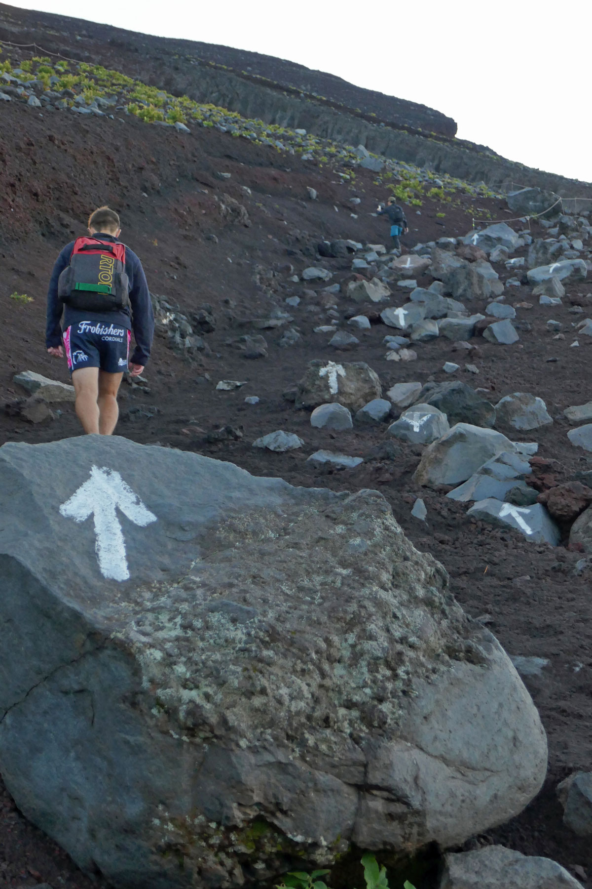
The trails are so well marked that a guide is not necessary if your only concerns are about navigation.
How fit should I be?
The truth is, a lot of people make it to the summit of Mount Fuji, including those who look like they’ve never exercised a day in their lives.
Better fitness will increase your chances of an enjoyable summit. If you’re planning to hike through the night, you’ll be battling with general tiredness as well as fatigue from the climb, so the better shape you are in when you start, the better you’ll handle the challenge.